Inside the Grand Canyon. South Kaibab - Tonto - Bright Angel. US Southwest trip Day 7 [POL / ENG]
"Inside the Grand Canyon" post is written in Polish and English. The English text is in italics, below each paragraph in Polish.
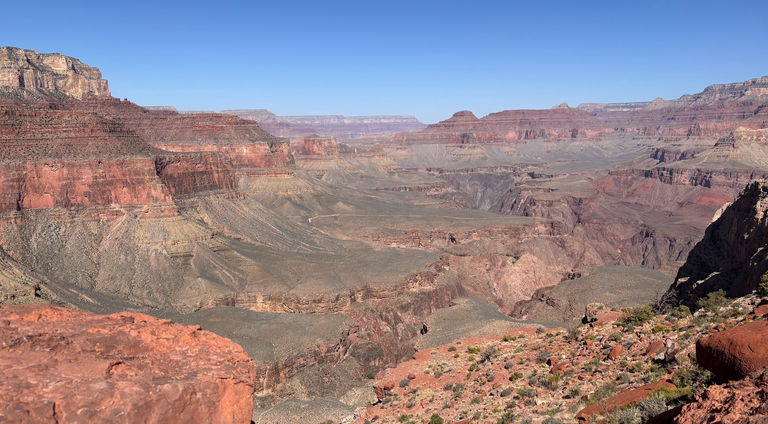
Wielki Kanion Kolorado został wpisany na naszą listę jako pierwsze miejsce do odwiedzenia. Trudno wyobrazić sobie podróż przez południowy zachód USA bez Wielkiego Kanionu (Arizona). Przeznaczyliśmy nań 2 dni. Pierwszego dnia przeszliśmy 20km wzdłuż południowego brzegu kanionu. Drugiego zeszliśmy w dół.
The Grand Canyon, Arizona is a must see during a first-time Southwestern US trip. We spent 2 days there. The first day was a walk along the south rim, from Kaibab Trailhead to Hermit's Rest. On the second day we descended into the abyss.
Plan
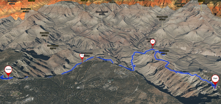
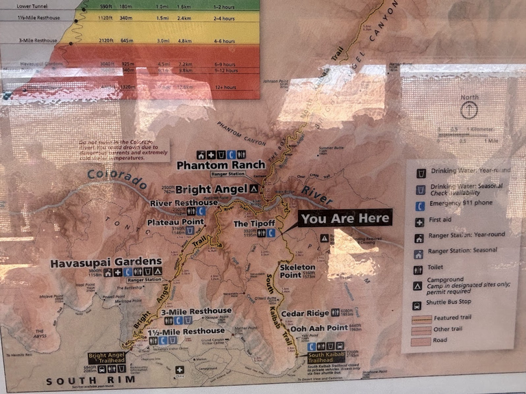
Logistykę znacznie upraszcza dostępność darmowych autobusów. Parkujemy przy Centrum Informacyjnym i busem linii pomarańczowej jedziemy do punktu South Kaibab Trailhead. Zejdziemy tym szlakiem 1 kilometr w głąb kanionu, do punktu Tipoff. Stamtąd wędrówka szlakiem Tonto do Havasupai Gardens. Powrót szlakiem Bright Angel. Zdradzę suspens - jeden z nas zszedł szlakiem South Kaibab na samo dno kanionu (1,5km w głąb!) i wrócił tą samą drogą.
The logistics of Grand Canyon is easy due to free shuttle buses. We parked at the Visitors Center and took the orange line to South Kaibab Trailhead. We descended 1 kilometer inside the Grand Canyon, to the Tipoff point. Then we hiked the Tonto trail to Havasupai Gardens. Bright Angel trail took as back to the rim. Spoiler alert - one of us continued on the South Kaibab trail all the way to the bottom (1.5km inside the Grand Canyon!) and returned the same way.
Into the Abyss
Zejście na dno Wielkiego Kanionu było marzeniem. Ostatecznie tylko jeden z naszej trójki zdecydował się na dotarcie na samo dno, do rzeki Kolorado. Ja spełniłem 2/3 tego marzenia - dotarliśmy do punktu Tipoff, czyli cały kilometr różnicy wysokości w głąb od brzegu kanionu. Następnie wędrowaliśmy mniej więcej na tej samej poziomicy, by wrócić na górę w okolicach Grand Canyon Village.
Descending inside the Grand Canyon had been our bucket list item. One of our trio did the full trip, into the abyss and back on the same day. I and the other companion descended 1 kilometer elevation loss into the abyss. We then traversed a plateau and returned to the rim at Grand Canyon Village.
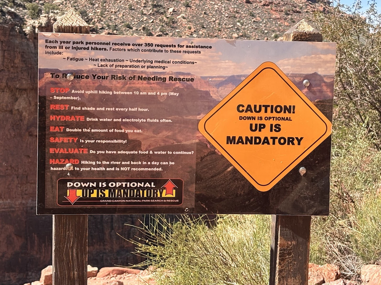
W Parku Narodowym Wielkiego Kanionu jest mnóstwo ostrzeżeń by nie schodzić na dno i wracać tego samego dnia. Dystans (ok. 18km) i suma przewyższeń (1800km) wymagają dobrej kondycji - ale mam takie wyprawy za pasem, jest to do zrobienia. Natomiast prawdziwym wyzwaniem jest upał i brak wody. Stąd decyzja dwójki z nas by nie schodzić na samo dno. Jeśli jesteście w kanionie po kwietniu, to do pomysłu zejścia i powrotu tego samego dnia należy podejść bardzo krytycznie. W kwietniu na dnie kanionu było 33° (to teoretyczna temperatura w cieniu, którego... nie ma. Nagrzane skały działają jak piekarnik, temperatura odczuwalna jest dużo wyższa), a później w sezonie jest już tylko gorzej.
In the Grand Canyon National Park there are plenty of warnings not to attempt to reach the bottom and return on the same day. The distance (18km) and elevation gain (1800m) are physically demanding - this said, we had done trails with similar parameters. The real challenge, however, is the heat and lack of water. Hence the decision of 2 out of our trio not to descend to the very bottom. If you happen to be in the Grand Canyon after April, be very careful with such ideas. In April, the temperature at the bottom was 33° centigrade. But this was a theoretical temperature in the shadow, which... is not there. Sandstone rocks absorb heat and make a furnace effect. Therefore the real feel is much higher. After April, this becomes only worse.
The Tipoff
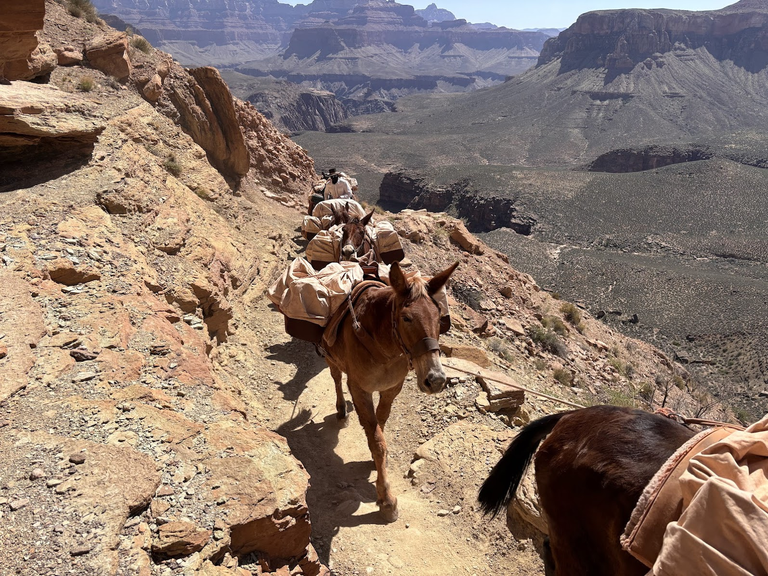
Istnieje możliwość przenocowania na dnie kanionu i wielu wędrowców z niej korzysta. W Phantom Ranch jest kilka domków i mały hostel. Ale uwaga - rezerwacje są prowadzone z 14-miesięcznym wyprzedzeniem! Zaopatrzenie dostarczane jest przez... muły. Jeśli spotkamy je na szlaku, zawsze ustępujemy im pierwszeństwa.
There is a possibility to stay overnight at the bottom of the canyon. Phantom Ranch offers a few cabins and dormitories. Reservations need to be made 14 months ahead! The only way to get provisions down and waste out, is by using mules. When we meet a mule train, we must always give way.
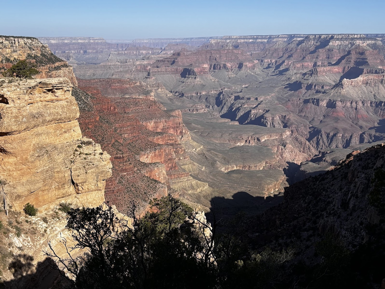
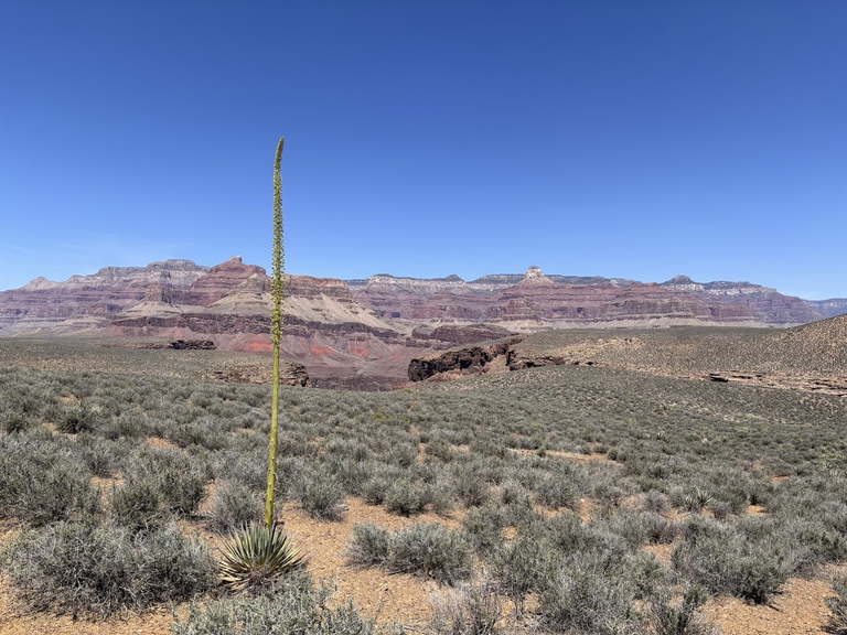
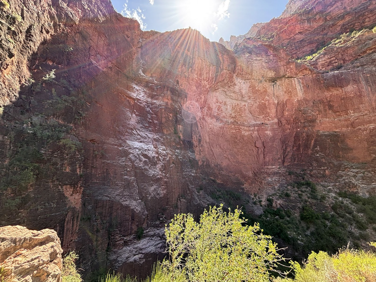
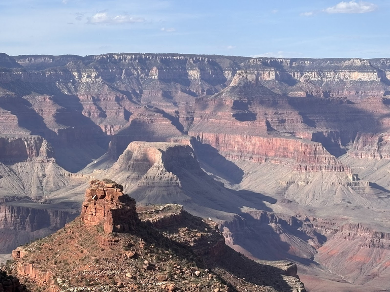
Schodząc na dno kanionu, przechodzimy przez kolejne warstwy geologiczne. Łatwo je rozpoznać po kolorze i strukturze skał. Przykładowo, w okolicach punktu Cedar Ridge piaskowiec wyraźnie zmienia się z beżowego na pomarańczowy. To idealna lekcja geologii.
Descending inside the Grand Canyon, we passed subsequent layers of rocks. At some point, between Cedar Ridge and Skeleton, the color changes from beige to orange. It's a perfect geology lesson.
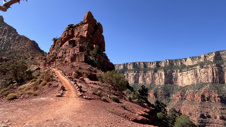
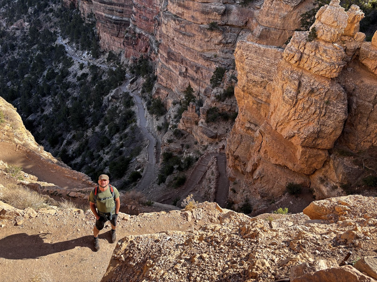
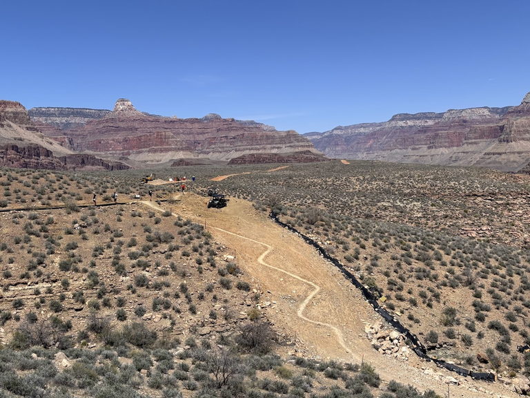
Docieramy do punktu Tipoff, który znajduje się na ósmym kilometrze szlaku, 1100m poniżej brzegu kanionu. Jest tam niewielka wiata i sucha toaleta. Nie ma wody pitnej. Dla dwójki z nas to najniższy punkt, kolega kontynuował na sam dół.
The Tipoff is the lowest point for two of us, while our companion continued further down. It is located on the 8th kilometer of the trail, 1100m below the canyon rim. There is a small shed and a dry toilet. No drinking water is available.

Tonto Trail
Na brzegu kanionu było przyjemne 18° . Im niżej, tym goręcej. Jeśli dotarliśmy do Tipoff i chcemy kontynuować na dno, warto zapoznać się z planszą, która pokazuje wzrost temperatury i szacowane czasy przejścia. Dystans do rzeki wydaje się niewielki, ale upał wyssie z nas energię. A trzeba jeszcze wrócić.
When we started, it was a pleasant 18° C at the rim. The lower we got, the hotter it was. If we reach the Tipoff and want to continue down, we should acquaint ourselves with information on estimated time and temperature growth. It looks like we are very close to the river, but the heat sucks off energy by the minute. Preserve enough to return to the rim.
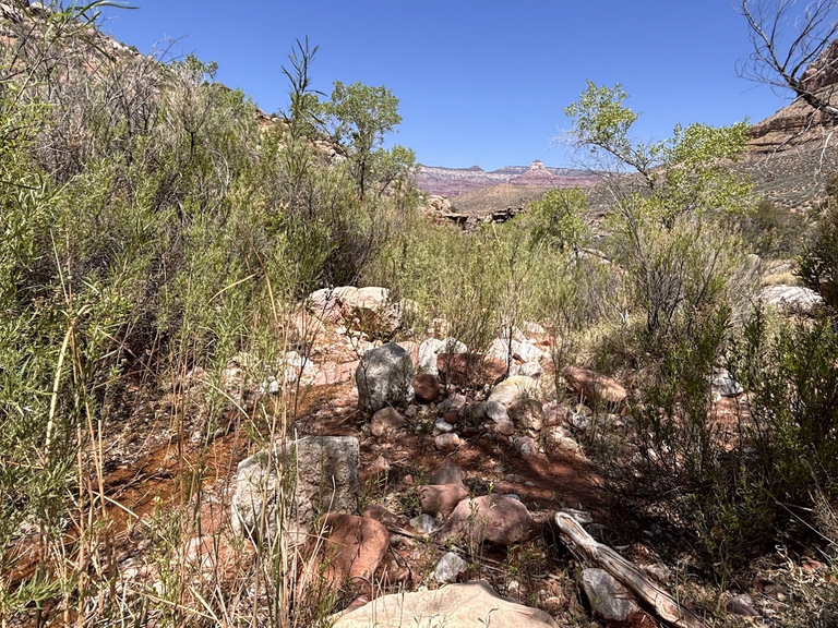
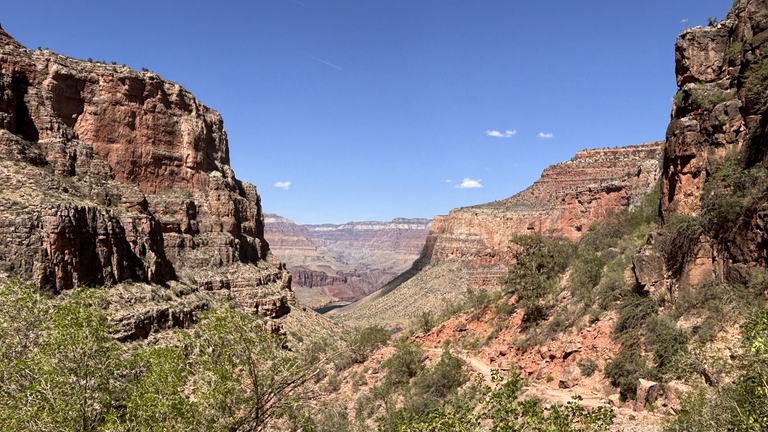
Dwoje z nas ruszyło na zachód szlakiem Tonto. Ten szlak jest relatywnie płaski, prowadzi po rozległym płaskowyżu mniej więcej kilometr poniżej brzegu kanionu. Płaskowyż jest porośnięty pustynną roślinnością. Wydaje się - spacer. Ale upał mówi inaczej.
Two of us went on west, following the Tonto trail. It is relatively flat, it follows a large plateau located about 1 kilometer down from the rim. There are some desert bushes. It seems like an easy stroll. But the heat makes it a challenge.
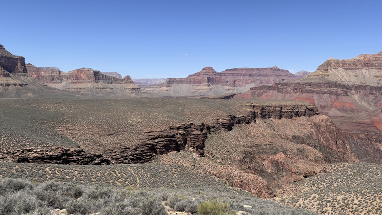
Płaskowyż jest poprzecinamy kilkoma bocznymi kanionami. By je przekroczyć, szlak prowadzi w stronę ich początku, gdzie są płytkie i wąskie. W dwóch z takich kanionów sączy się woda. Roślinność tylko na to czeka - te miejsca są jak oazy.
The plateau is cut by a few side canyons. To go over the other side, the trail veers towards their origins, where they are shallow and narrow. In two of such side canyons water is trickling. These places are the only oasis of green.
Na dwie osoby mieliśmy 5 litrów wody. To mniej niż zalecany galon (3,8 litra) na osobę. Wodę należy pić regularnie, małymi łykami. Dobrze jest mieć słone przekąski, na przykład orzeszki i podjadać co godzinę. W ten sposób zatrzymujemy sole mineralne i ograniczamy ryzyko odwodnienia.
We had 5 liters of water between the two of us. It is less than recommended gallon (3.8 liter) per person. Water must be drank in regular intervals, taking small sips. It is advised to have some salty snacks, like nuts, and eat some every hour. In this way we keep salt in and limit the risk of dehydrating.
Havasupai Gardens
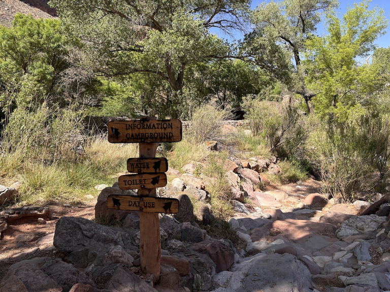
Od parkowego rangersa spotkanego na początku szlaku dowiedzieliśmy się, że na 15-tym kilometrze, w oazie Havasupai Gardens, będzie pitna woda. Bez tej świadomości pozornie łatwy odcinek szlakiem Tonto byłby mentalnie bardzo trudny - musielibyśmy oszczędzać wodę na wyjście z kanionu.
A park ranger we had met earlier told us that drinking water would be available at Havasupai Gardens (15km from start). It was a refreshing knowledge - without it the seemingly easy Tonto trail would have been mentally challenging - we would have had to ration water, to save it for the ascent back to the rim.
Woda z Havasupai Gardens była zimna i odświeżająca. Mało kiedy doceniamy jakim jest błogosławieństwem, a przecież wielu ludzi na Ziemi nie ma stałego dostępu do czystej, pitnej wody. Pijemy i napełniamy wszystkie bidony do pełna. Kilka lat wcześniej, w Izraelu, podpatrzyłem jak przewodnik na pustyni nalewa wodę do kapelusza i wkłada go na głowę. Zrobiłem to samo.
The water from Havasupai Gardens was cold and refreshing. We rarely appreciate the blessing of water. Many people on Earth don't have easy access to clean potable water. We drank and refilled all our bottles. Following the example of an guide I had met in Israel some years prior, I poured some water into my hat and put it on my head.
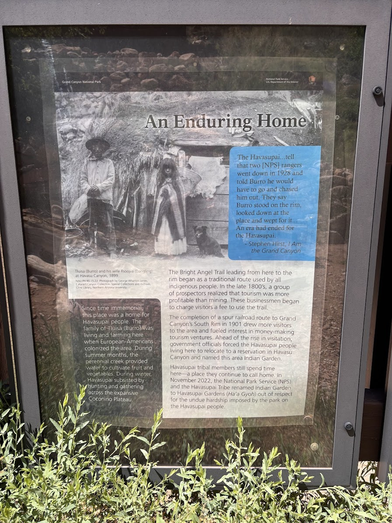
Havasupai to nazwa plemienia, które mieszkało w okolicy. Miejsce, które obecnie służy odświeżeniu turystów, było wioską indiańską. Nie było łatwo tu przeżyć - trzeba było zmierzyć się z surowymi zimami i gorącymi latami. A wyjście z wioski, np. "na zakupy", oznaczało nużącą wędrówkę w górę kanionu. 1000m różnicy wysokości!
Havasupai were the native people who used to live in the vicinity. The place used to be a small village. It wasn't an idyllic life - winters are harsh and summers are very hot here. And think that every "grocery trip" meant hiking up to the canyon rim - 1000m of elevation gain!
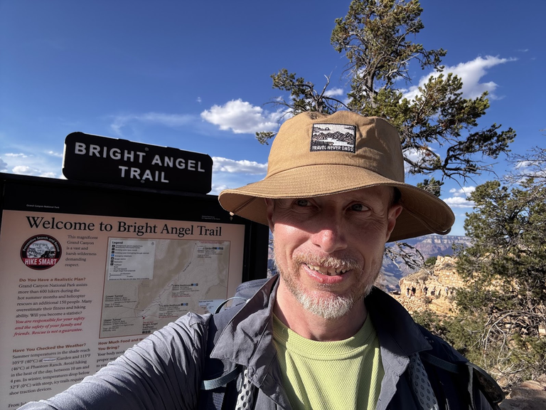
Bright Angel Trail
Na górę wyprowadzi nas szlak Bright Angel. Zostało nam zaledwie 7km do końca. Ale te 7km to ponad 1000m różnicy wysokości. Mamy zapas wody, po drodze będzie jeszcze można uzupełnić. Upał jednak mocno daje się we znaki. A jest kwiecień! Nie wyobrażam sobie tej wędrówki w lipcu.
We will get out of the canyon by the Bright Angel trail. We have just 7km to go. But these 7 kilometers mean over 1000m of elevation gain. We have enough water and there will be a refilling station. The heat, however, is enormous. And this is April - I cannot imagine hiking there in July!
Szlak Bright Angel wytyczyli rdzenni mieszkańcy. Był dla nich jedynym wyjściem na świat. W 1890r na brzegu kanionu osiedlił się Ralph Cameron, biznesman i późniejszy senator z Arizony. Cameron poszerzył stary indiański szlak i zaczął pobierać opłaty - 1$ za przejście i dodatkowo za wodę w Havasupai Gardens. Na początku XX wieku, kiedy powstawał Park Narodowy Wielkiego Kanionu, prezydent Theodore Roosevelt nakazał przymusową eksmisję plemienia Havasupai.
The Bright Angel trail had been originally traced by the Havasupai. It was their only window into the wider world. In 1890, Ralph Cameron, a businessman and future senator from Arizona, settled near the rim. He improved the Havasupai trail and started collecting tolls - $1 for passing and additional fee for water in Havasupai Gardens. At the beginning of the 20th century, when the Grand Canyon National Park was created, president Theodore Roosevelt ordered a forced eviction of the Havasupai from their land.
Jeszcze raz powtórzę, że wędrówka na brzeg kanionu jest wyczerpująca. Służby parkowe zalecają wręcz żeby w lecie (maj - wrzesień) nie wychodzić na górę pomiędzy 10 rano a 4 po południu. I przede wszystkim pamiętamy o odpowiednim nawodnieniu.
Let me state again that the trek from Havasupai Gardens to the canyon rim is exhausting. The park services recommend not to hike between 10am and 4pm during the long summer (May - September). Proper hydration is the key.
Zmęczeni ale szczęśliwi wychodzimy na brzeg kanionu. Jesteśmy w Grand Canyon Village, gdzie nie brakuje opcji gastronomicznych. My jednak zjemy później, a teraz darmowym busem (linia niebieska) pojechaliśmy na parking przy Centrum Informacyjnym. Kolega, który zszedł na samo dno (wrócił tak samo jak schodził), już tam na nas czekał.
Tired but happy, we emerged from the abyss near the Grand Canyon Village. It offers many eating options. We, however, took the blue shuttle and headed to the parking near Visitor's Center. Our friend, who had gone to the very bottom of canyon and returned back, was already waiting there for us.
America the Beautiful Trip - Day 7
Inside the Grand Canyon
| Data / Date | 24.04.2025 |
|---|---|
| Poprzedni dzień / Previous day | Grand Canyon South Rim |
| Trasa samochodem / Route by car | Valle <=> Grand Canyon Village (90km) |
| Szlak(i) pieszo / Trail(s) on foot | Inside the Grand Canyon hike (22km, 1283m total elevation gain) |
| Wstęp / Entry fee | America the Beautiful Annual Pass |
| Strona www Parku / Park website | https://www.nps.gov/grca/index.htm |
| Nocleg / Accommodation | Grand Canyon Inn & Motel - South Rim Entrance, AZ |
| Następny dzień / Next day | Route 66 and Hoover Dam |
| Plan podróży / Trip itinerary | 'America the Beautiful Trip' |
You can check out this post and your own profile on the map. Be part of the Worldmappin Community and join our Discord Channel to get in touch with other travelers, ask questions or just be updated on our latest features.
Congratulations, your post has been added to the TravelFeed Map! 🎉🥳🌴
Did you know you have your own profile map?
And every post has their own map too!
Want to have your post on the map too?
- Go to TravelFeed Map
- Click the create pin button
- Drag the marker to where your post should be. Zoom in if needed or use the search bar (top right).
- Copy and paste the generated code in your post (any Hive frontend)
- Or login with Hive Keychain or Hivesigner and click "create post" to post to Hive directly from TravelFeed
- Congrats, your post is now on the map!
PS: You can import your previous Pinmapple posts to the TravelFeed map.Opt Out
Hiya, @ybanezkim26 here, just swinging by to let you know that this post made it into our Top 3 in Travel Digest #2625.
Your post has been manually curated by the @worldmappin team. If you like what we're doing, please drop by to check out all the rest of today's great posts and consider supporting other authors like yourself and us so we can keep the project going!
Become part of our travel community:
https://www.reddit.com/r/mountains/comments/1m3z5u7/the_grand_canyon_arizona/
This post has been shared on Reddit by @yale95reyra through the HivePosh initiative.
https://x.com/TravelfeedP/status/1946920834603319441
Congratulations @klub-wloczykijow! You received the biggest smile and some love from TravelFeed! Keep up the amazing blog. 😍 Your post was also chosen as top pick of the day and is now featured on the TravelFeed front page.
Thanks for using TravelFeed!
@lesiopm (TravelFeed team)
PS: Did you know that we launched the truvvl app? With truvvl, you can create travel stories on the go from your phone and swipe through nearby stories from other TravelFeed users. It is available on the Apple App Store and Google Play.
Hello klub-wloczykijow!
It's nice to let you know that your article will take 4th place.
Your post is among 15 Best articles voted 7 days ago by the @hive-lu | King Lucoin Curator by szejq
You receive 🎖 2.2 unique LUBEST tokens as a reward. You can support Lu world and your curator, then he and you will receive 10x more of the winning token. There is a buyout offer waiting for him on the stock exchange. All you need to do is reblog Daily Report 728 with your winnings.
Buy Lu on the Hive-Engine exchange | World of Lu created by szejq
STOPor to resume write a wordSTART